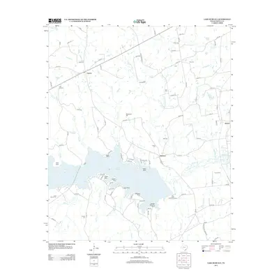
2013 Map of Lake Murvaul
USGS Topo · Published 2013About this map
Lake Murvaul dominates this landscape in Panola County, its intricate shoreline defined by numerous points and creek inlets like Smith Point and Witherspoon Br. The map documents a rural East Texas community organized around the settlements of Clayton and Buncome, where the land begins to rise toward Stonewall Hill. Genealogists will find a significant concentration of family and community burial grounds, including the Heath Long Cem, Ross Etheridge Cem, and Snap Cem. The presence of the Boy Scouts of America Camp on the southern shore of the reservoir highlights the area's transition toward recreation, while the dense network of county roads like Lakeshore Dr and Co RD-1754 reflects the local infrastructure supporting these lakeside communities and traditional timber or ranching tracts.
Find a feature on this map
106 named features on this map. Tap any name to fly to it.
Don’t see what you’re looking for? This feature index may not catch every label — zoom into the map to look around manually.
Map Details
Editions of this 2013 Lake Murvaul Map
This is the sole edition of this map. No revisions or reprints were ever made.
Other maps of this area

1953 · Palestine
USGS Topo · 1:250,000

1956 · Tyler
USGS Topo · 1:250,000

1957 · Palestine
USGS Topo · 1:250,000

1958 · Timpson
USGS Topo · 1:62,500

1958 · Carthage
USGS Topo · 1:62,500

1960 · Minden
USGS Topo · 1:62,500

1960 · Mount Enterprise
USGS Topo · 1:62,500

1983 · Long Branch
USGS Topo · 1:24,000

1983 · Fair Play
USGS Topo · 1:24,000
1983 · Gary
USGS Topo · 1:24,000