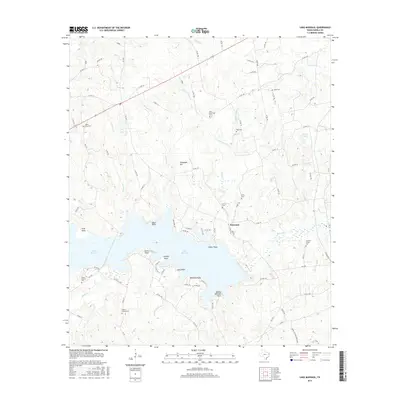
2016 Map of Lake Murvaul
USGS Topo · Published 2016About this map
Lake Murvaul dominates the landscape of Panola County, its irregular shoreline punctuated by numerous named points including Smith Point, Lampin Point, and Ritter Point. This 2016 survey illustrates the modern topography of the area near Buncome, where the water is fed by a network of tributaries such as Sixmile Cr, Fallwell Cr, and Murvaul Cr. The map is particularly useful for genealogical research, identifying many family-named and community burial grounds scattered across the terrain, from the Thomas Family Cem in the east to the Heath Cem and Union Murvaul Cem in the west. Elevated terrain like Stonewall Hill rises above the drainage basins of Indian Cr and Davis Br, showing the contrast between the low-lying wetlands and the surrounding ridges in this portion of East Texas.
Find a feature on this map
105 named features on this map. Tap any name to fly to it.
Don’t see what you’re looking for? This feature index may not catch every label — zoom into the map to look around manually.
Map Details
Editions of this 2016 Lake Murvaul Map
This is the sole edition of this map. No revisions or reprints were ever made.
Other maps of this area

1953 · Palestine
USGS Topo · 1:250,000

1956 · Tyler
USGS Topo · 1:250,000

1957 · Palestine
USGS Topo · 1:250,000

1958 · Timpson
USGS Topo · 1:62,500

1958 · Carthage
USGS Topo · 1:62,500

1960 · Minden
USGS Topo · 1:62,500

1960 · Mount Enterprise
USGS Topo · 1:62,500

1983 · Long Branch
USGS Topo · 1:24,000

1983 · Fair Play
USGS Topo · 1:24,000
1983 · Gary
USGS Topo · 1:24,000