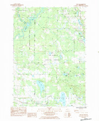
1984 Map of Lake NE
USGS Topo · Published 1984About this map
The Muskegon River winds through the northwestern corner of this landscape, marking a terrain defined by glacial lakes and heavy forest cover along the boundary of Osceola and Clare Counties. In the early 1980s, this region was a significant intersection of recreational conservation and industrial energy extraction. Public lands like the Pere Marquette State Forest and Au Sable State Forest dominate the central portion of the map, while the Freeman-Lincoln Gas Storage Field and Freeman Redding Oil Field highlight the subsurface resource economy of the era. Settlement is sparse, anchored by the Townhall and the David Helm Chapel near a cluster of small lakes. The southern reach is defined by the North Branch Chippewa River and the tracks of the Chesapeake and Ohio railroad, providing a clear view of the transportation corridors that historically supported the local timber and energy sectors.
Find a feature on this map
41 named features on this map. Tap any name to fly to it.
Don’t see what you’re looking for? This feature index may not catch every label — zoom into the map to look around manually.
Map Details
Editions of this 1984 Lake NE Map
This is the sole edition of this map. No revisions or reprints were ever made.
Other maps of this area

1954 · Traverse City
USGS Topo · 1:250,000

1954 · Midland
USGS Topo · 1:250,000

1957 · Harrison
USGS Topo · 1:62,500

1957 · Marion
USGS Topo · 1:62,500

1958 · Traverse City
USGS Topo · 1:250,000

1958 · Midland
USGS Topo · 1:250,000

1959 · Midland
USGS Topo · 1:250,000

1959 · Lake
USGS Topo · 1:62,500

1959 · Clare
USGS Topo · 1:62,500

1966 · Midland
USGS Topo · 1:250,000
Featured Places
- Sylvan Township, MI
- Freeman Township, MI
- Garfield Township, MI
- Middle Branch Township, MI
- Orient Township, MI