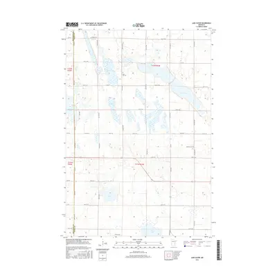
2016 Map of Lake Oliver
USGS Topo · Published 2016About this map
The county boundary between Big Stone and Swift Counties defines this agricultural landscape in western Minnesota, where glacial depressions have created a dense network of prairie lakes. The namesake Lake Oliver dominates the northeastern quadrant, part of a larger chain that includes Large Henry Lake and the smaller Long Lake. This 2016 survey illustrates the persistent rural infrastructure of the region, anchored by historical burial sites that serve as anchors for local genealogy. Waldum Cem is situated near the northern border, while Long Lake Cem and Immanuel Cem are positioned centrally and to the east, respectively. The land is strictly organized by the Public Land Survey System, with a grid of gravel and paved routes such as Co Rd 24 and Co Rd 58 providing access to the fertile plains surrounding Artichoke Lake and Shible Lake.
Find a feature on this map
30 named features on this map. Tap any name to fly to it.
Don’t see what you’re looking for? This feature index may not catch every label — zoom into the map to look around manually.
Map Details
Editions of this 2016 Lake Oliver Map
This is the sole edition of this map. No revisions or reprints were ever made.
Other maps of this area

1953 · Milbank
USGS Topo · 1:250,000

1953 · Saint Cloud
USGS Topo · 1:250,000

1957 · Saint Cloud
USGS Topo · 1:250,000

1958 · Milbank
USGS Topo · 1:250,000

1958 · Saint Cloud
USGS Topo · 1:250,000

1958 · Correll
USGS Topo · 1:24,000

1958 · Milan NW
USGS Topo · 1:24,000

1958 · Appleton
USGS Topo · 1:24,000

1968 · Dry Wood Lake
USGS Topo · 1:24,000

1968 · Lake Oliver
USGS Topo · 1:24,000