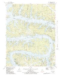
1983 Map of Lake Ozark
USGS Topo · Published 1983About this map
Bagnell Dam anchors this early 1980s survey, illustrating the complex, finger-like shoreline of the Lake of the Ozarks Osage River as it winds through Miller, Morgan, and Camden counties. The topography reflects a landscape transformed by hydroelectric development, yet it remains deeply tied to its earlier geography through numerous family cemeteries such as Birdsong Cem and Anderson Cem. The settlement pattern centers on recreation and residential growth in Lake Ozark, Lakeland, and Osage Beach, where modern amenities like the Golf Course and School of the Osage contrast with the rugged relief of Carrot Bluff and Bald Ridge. A notable detail of this edition is the inclusion of underwater contours derived from 1925 and 1931 Union Electric Company charts, revealing the original river channel and submerged terrain of Kinchlow Hollow Cove and Jennings Branch Cove before the reservoir was filled.
Find a feature on this map
73 named features on this map. Tap any name to fly to it.
Don’t see what you’re looking for? This feature index may not catch every label — zoom into the map to look around manually.
Map Details
Editions of this 1983 Lake Ozark Map
3 editions found
Other maps of this area

1888 · Versailles
USGS Topo · 1:125,000

1893 · Versailles
USGS Topo · 1:125,000

1904 · Eldon
USGS Topo · 1:62,500

1904 · Gravois Mills
USGS Topo · 1:62,500

1932 · Versailles No 4
USGS Topo · 1:48,000

1934 · Camdenton
USGS Topo · 1:24,000

1934 · Purvis
USGS Topo · 1:24,000

1934 · Toronto
USGS Topo · 1:24,000

1934 · Lake Ozark
USGS Topo · 1:24,000

1934 · Bagnell
USGS Topo · 1:24,000