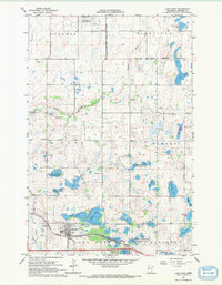
1966 Map of Lake Park
USGS Topo · Published 1967About this map
Lake Park serves as a vital hub for this mid-1960s landscape, situated along the Northern Pacific railroad and surrounded by a dense network of prairie lakes. The village layout shows clear industrial and utility footprints, including a Sewage Disposal plant and several elevators near the tracks. To the north and east, the transition into the White Earth Indian Reservation is marked across the drainage of the Buffalo River, highlighting the intersection of tribal and municipal lands.
Find a feature on this map
34 named features on this map. Tap any name to fly to it.
Don’t see what you’re looking for? This feature index may not catch every label — zoom into the map to look around manually.
Map Details
Editions of this 1966 Lake Park Map
This is the sole edition of this map. No revisions or reprints were ever made.
Other maps of this area

1918 · Flom
USGS Topo · 1:62,500

1952 · Grand Forks
USGS Topo · 1:250,000

1953 · Fargo
USGS Topo · 1:250,000

1953 · Brainerd
USGS Topo · 1:250,000

1954 · Bemidji
USGS Topo · 1:250,000

1956 · Fargo
USGS Topo · 1:250,000

1956 · Grand Forks
USGS Topo · 1:250,000

1957 · Brainerd
USGS Topo · 1:250,000

1957 · Bemidji
USGS Topo · 1:250,000

1958 · Bemidji
USGS Topo · 1:250,000