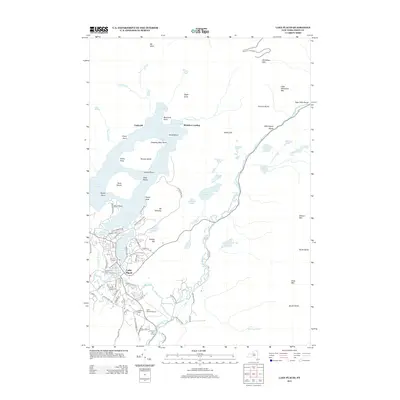
2013 Map of Lake Placid
USGS Topo · Published 2013About this map
The mountain town of Lake Placid serves as the hub of this High Peaks survey, showcasing a landscape defined by winter sports heritage and deep glacial waters. The village center is densely mapped between the shores of Mirror Lake and the Chubb River, featuring landmarks of international athletic history including the Olympic Arena and the Olympic Ski Jump near the Lake Placid Airport. To the north, the waters of Lake Placid are interrupted by large landmasses such as Moose Island and Buck Island, while the shoreline reaches remote landings like Undercliff and Whiteface Landing. The terrain rises sharply toward the northeast, dominated by the massif of Whiteface Mtn and the narrow passage of Wilmington Notch where the W Br Ausable River flows. This era of the landscape shows a clear transition from the quiet settlement around the N Elba Cem to a modern center of recreation and aviation.
Find a feature on this map
100 named features on this map. Tap any name to fly to it.
Don’t see what you’re looking for? This feature index may not catch every label — zoom into the map to look around manually.
Map Details
Editions of this 2013 Lake Placid Map
This is the sole edition of this map. No revisions or reprints were ever made.
Other maps of this area

1895 · Mt. Marcy
USGS Topo · 1:62,500

1896 · Lake Placid
USGS Topo · 1:62,500

1898 · Lake Placid
USGS Topo · 1:62,500

1902 · Mt. Marcy
USGS Topo · 1:62,500

1902 · Saranac
USGS Topo · 1:62,500

1904 · Saranac
USGS Topo · 1:62,500

1904 · Santanoni
USGS Topo · 1:62,500

1948 · Ogdensburg
USGS Topo · 1:250,000

1950 · Lake Champlain
USGS Topo · 1:250,000

1951 · Ogdensburg
USGS Topo · 1:250,000