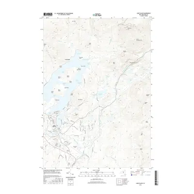
2016 Map of Lake Placid
USGS Topo · Published 2016About this map
John Browns Grave and the North Elba Cem ground the southern valley of this High Peaks landscape, which centers on the dual waters of Lake Placid and Mirror Lake. The village of Lake Placid serves as the primary hub, with a dense network of residential streets such as Hillcrest Ave and Grandview Ave rising toward Cobble Hill. The topography is dominated by the massive profile of Whiteface Mtn and the Sentinel Range, where the West Branch Ausable River carves through the narrow Wilmington Notch. Recreation and conservation efforts are evident in the winding Jackrabbit Trail and the placement of the Lake Placid Airport. Water bodies like Connery Pond and Owen Pond are scattered throughout the northern reaches, while the isolated settlement of Undercliff sits on the western shore of the main lake, accessible primarily by water.
Find a feature on this map
105 named features on this map. Tap any name to fly to it.
Don’t see what you’re looking for? This feature index may not catch every label — zoom into the map to look around manually.
Map Details
Editions of this 2016 Lake Placid Map
This is the sole edition of this map. No revisions or reprints were ever made.
Other maps of this area

1895 · Mt. Marcy
USGS Topo · 1:62,500

1896 · Lake Placid
USGS Topo · 1:62,500

1898 · Lake Placid
USGS Topo · 1:62,500

1902 · Mt. Marcy
USGS Topo · 1:62,500

1902 · Saranac
USGS Topo · 1:62,500

1904 · Saranac
USGS Topo · 1:62,500

1904 · Santanoni
USGS Topo · 1:62,500

1948 · Ogdensburg
USGS Topo · 1:250,000

1950 · Lake Champlain
USGS Topo · 1:250,000

1951 · Ogdensburg
USGS Topo · 1:250,000