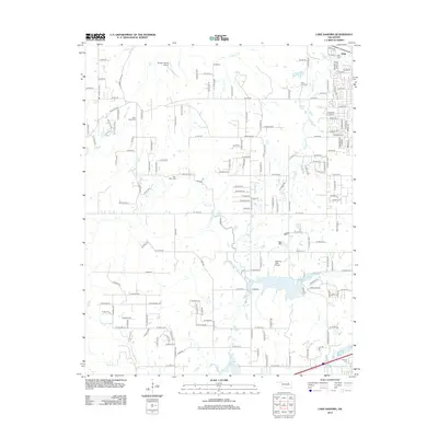
2012 Map of Lake Sahoma
USGS Topo · Published 2012About this map
Sahoma Lake and the surrounding Creek County countryside are defined by a complex network of reservoirs and rural homesteads west of the main Sapulpa settlement. This 2012 survey illustrates the hydrological importance of Sapulpa Lake and Pretty Water Lake, which are fed by winding tributaries like Rock Cr and Fisher Cr. The map reveals a landscape still rooted in local history, featuring several family and community burial grounds such as Tiger Bone Cem, Post Oak Cem, and Rock Creek Cem. Aviation interest is evident in the presence of both the Sahoma Lake Airport and the Flying G Ranch Airport, indicating a mix of recreational and private utility. The layout of county roads, including W 41st St and W 51st St, provides a framework for the residential expansion and agricultural plots that dot the terrain between Euchee Cr and the small northern settlement of Shirk.
Find a feature on this map
145 named features on this map. Tap any name to fly to it.
Don’t see what you’re looking for? This feature index may not catch every label — zoom into the map to look around manually.
Map Details
Editions of this 2012 Lake Sahoma Map
This is the sole edition of this map. No revisions or reprints were ever made.
Other maps of this area

1901 · Nuyaka
USGS Topo · 1:125,000

1912 · Hominy
USGS Topo · 1:125,000

1914 · Kiefer
USGS Topo · 1:62,500

1915 · Hominy
USGS Topo · 1:125,000

1916 · Kiefer
USGS Topo · 1:62,500

1916 · Bristow
USGS Topo · 1:62,500

1954 · Oklahoma City
USGS Topo · 1:250,000

1955 · Enid
USGS Topo · 1:250,000

1956 · Sand Springs
USGS Topo · 1:24,000

1956 · Sapulpa North
USGS Topo · 1:24,000