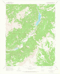
1964 Map of Lake San Cristobal
USGS Topo · Published 1967About this map
Lake San Cristobal dominates the center of this high-elevation Colorado landscape, situated along the Gunnison River and the Slumgullion Creek drainage. The mapping reveals a terrain shaped by geology and extraction, featuring the massive Slumgullion Slide and various unnamed Mines and a specific Mine tucked into the mountain gulches. Human presence is marked by scattered infrastructure including a Radio Tower, a Landing Strip near Castle Lakes, and a small Cem overlooking the river valley.
Find a feature on this map
34 named features on this map. Tap any name to fly to it.
Don’t see what you’re looking for? This feature index may not catch every label — zoom into the map to look around manually.
Map Details
Editions of this 1964 Lake San Cristobal Map
4 editions found
Other maps of this area

1903 · Lake City
USGS Topo · 1:62,500

1905 · Lake City
USGS Topo · 1:62,500

1905 · San Cristobal
USGS Topo · 1:125,000

1907 · San Cristobal
USGS Topo · 1:125,000

1908 · Uncompahgre
USGS Topo · 1:125,000

1911 · Uncompahgre
USGS Topo · 1:125,000

1945 · Durango
USGS Topo · 1:250,000

1953 · Durango
USGS Topo · 1:250,000

1954 · Durango
USGS Topo · 1:250,000

1956 · Montrose
USGS Topo · 1:250,000