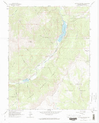
1964 Map of Lake San Cristobal
USGS Topo · Published 1973About this map
Lake San Cristobal dominates the center of this high-elevation terrain, where the Lake Fork of the Gunnison River is squeezed between dramatic geologic formations. The most prominent of these is the massive Slumgullion Slide, which descends from near Slumgullion Creek to form the natural dam that created the lake itself. Human presence is clustered at the southern end near Castle Lakes, which features a small Landing Strip and a nearby Cem.
Find a feature on this map
44 named features on this map. Tap any name to fly to it.
Don’t see what you’re looking for? This feature index may not catch every label — zoom into the map to look around manually.
Map Details
Editions of this 1964 Lake San Cristobal Map
4 editions found
Other maps of this area

1903 · Lake City
USGS Topo · 1:62,500

1905 · Lake City
USGS Topo · 1:62,500

1905 · San Cristobal
USGS Topo · 1:125,000

1907 · San Cristobal
USGS Topo · 1:125,000

1908 · Uncompahgre
USGS Topo · 1:125,000

1911 · Uncompahgre
USGS Topo · 1:125,000

1945 · Durango
USGS Topo · 1:250,000

1953 · Durango
USGS Topo · 1:250,000

1954 · Durango
USGS Topo · 1:250,000

1956 · Montrose
USGS Topo · 1:250,000