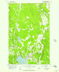
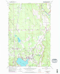
1956 Map of Lake Stevens
USGS Topo · Published 1957About this map
The town of Lake Stevens and the surrounding Snohomish County landscape are defined by a mix of early timber-era settlements and burgeoning mid-century residential growth. This mid-1950s record shows the Northern Pacific railroad corridor connecting small communities like Getchell and Hartford, which served as historical junctions for the region's movement of goods and people. To the north, the South Fork Stillaguamish River cuts through the terrain near Riverside, while local landmarks like the Granville Grange and Community Hall at Sisco Heights reflect the area's strong agrarian and civic roots. The map captures a transition as lakeside recreation and youth forestry programs, such as the Paul Sevenich Boy Scout Camp, established a permanent presence alongside older rural schools like East Sunnyside Sch and Mt Pilchuck School.
Find a feature on this map
50 named features on this map. Tap any name to fly to it.
Don’t see what you’re looking for? This feature index may not catch every label — zoom into the map to look around manually.
Map Details
Editions of this 1956 Lake Stevens Map
5 editions found
Other maps of this area

1895 · Snohomish
USGS Topo · 1:125,000

1897 · Seattle
USGS Topo · 1:125,000

1899 · Stillaguamish
USGS Topo · 1:125,000

1901 · Stilaguamish
USGS Topo · 1:125,000

1911 · Mount Vernon
USGS Topo · 1:125,000

1921 · Sultan
USGS Topo · 1:125,000

1923 · Sultan
USGS Topo · 1:125,000

1941 · Marysville
USGS Topo · 1:62,500

1943 · Marysville
USGS Topo · 1:62,500

1944 · Everett
USGS Topo · 1:62,500