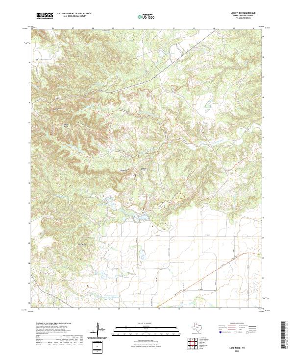
2022 Map of Lake Theo
USGS Topo · Published 2022About this map
The confluence of the N Prong Little Red River and S Prong Little Red River dominates this portion of Briscoe County, where the high plains break into a complex network of canyons and ridges. A distinct system of recreational and ranching trails, including the Haynes Ridge Overlook Trl and Canyon Rim Trl, provides access to landmarks like Eagles Point and a Natural Bridge. The landscape is defined by its water management and erosion patterns, evidenced by the Soil Conservation Service Site 2 Reservoir and numerous small water bodies such as Lake Theo and Hawkins Lake. To the north, the terrain levels out towards South Draw, while the southern reaches are marked by the prominent Old Flat Top and the winding course of Kent Cr. This 2022 survey illustrates the modern intersection of conservation efforts, rural infrastructure like Ranch Rd 1065, and the enduring topography of the Texas Panhandle.
Find a feature on this map
53 named features on this map. Tap any name to fly to it.
Don’t see what you’re looking for? This feature index may not catch every label — zoom into the map to look around manually.
Map Details
Editions of this 2022 Lake Theo Map
This is the sole edition of this map. No revisions or reprints were ever made.
Other maps of this area

1954 · Plainview
USGS Topo · 1:250,000

1958 · Plainview
USGS Topo · 1:250,000

1960 · Indian Peak
USGS Topo · 1:62,500

1960 · Brice
USGS Topo · 1:62,500

1967 · Quitaque
USGS Topo · 1:24,000

1967 · Edgemon Lake
USGS Topo · 1:24,000

1967 · Hay Lake
USGS Topo · 1:24,000

1967 · Turkey
USGS Topo · 1:24,000

1967 · Lake Theo
USGS Topo · 1:24,000
1967 · Folley
USGS Topo · 1:24,000