
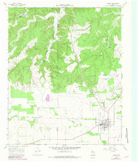
1967 Map of Turkey
USGS Topo · Published 1970About this map
The town of Turkey serves as the focal point of this Panhandle landscape, where the agricultural plains meet the broken terrain of the Caprock. Situated along the Fort Worth and Denver railroad, the community is mapped in detail including its High Sch, an Athletic Field, and a local Substa. A Drive-in Theater sits on the southern outskirts, reflecting the mid-century social character of Hall County.
Find a feature on this map
39 named features on this map. Tap any name to fly to it.
Don’t see what you’re looking for? This feature index may not catch every label — zoom into the map to look around manually.
Map Details
Editions of this 1967 Turkey Map
2 editions found
Other maps of this area

1954 · Plainview
USGS Topo · 1:250,000

1958 · Plainview
USGS Topo · 1:250,000

1960 · Indian Peak
USGS Topo · 1:62,500

1960 · Brice
USGS Topo · 1:62,500

1967 · Quitaque
USGS Topo · 1:24,000

1967 · North Windmill
USGS Topo · 1:24,000

1967 · Tampico Siding
USGS Topo · 1:24,000

1967 · Lake Theo
USGS Topo · 1:24,000
1967 · Folley
USGS Topo · 1:24,000

1976 · Brice SE
USGS Topo · 1:24,000