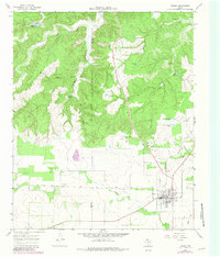
1967 Map of Turkey
USGS Topo · Published 1981About this map
The town of Turkey serves as the hub of this Panhandle landscape, where the flat plains of the Caprock transition into a labyrinth of erosional features. The Fort Worth and Denver railroad cuts across the lower half of the quadrangle, facilitating the movement of cattle and crops through this rural corridor. North of the settlement, the terrain drops away into the dramatic incisions of Lost Mule Canyon and Gyp Canyon, where the Little Red River meanders through a complex network of draws and breaks.
Find a feature on this map
33 named features on this map. Tap any name to fly to it.
Don’t see what you’re looking for? This feature index may not catch every label — zoom into the map to look around manually.
Map Details
Editions of this 1967 Turkey Map
2 editions found
Other maps of this area

1954 · Plainview
USGS Topo · 1:250,000

1958 · Plainview
USGS Topo · 1:250,000

1960 · Indian Peak
USGS Topo · 1:62,500

1960 · Brice
USGS Topo · 1:62,500

1967 · Quitaque
USGS Topo · 1:24,000

1967 · North Windmill
USGS Topo · 1:24,000

1967 · Tampico Siding
USGS Topo · 1:24,000

1967 · Turkey
USGS Topo · 1:24,000

1967 · Lake Theo
USGS Topo · 1:24,000
1967 · Folley
USGS Topo · 1:24,000