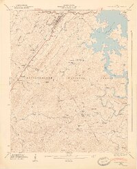
1947 Map of Lake Toccoa
USGS Topo · Published 1947About this map
The Toccoa River winds through the heart of the Chattahoochee National Forest on this 1947 survey, just as the Lake Toccoa reservoir had established its modern shoreline. This period shows a landscape defined by the Blue Ridge Divide and the busy corridor of the Louisville and Nashville railroad. Rural life is anchored by community landmarks such as Cherrylog Sch and the Snake Nation Sch, while the economic history of the area is visible in local milling operations like Elrod Mill, Ballew Mill, and Stewart Mill. A notable crossing is recorded at the Shallowford Bridge, providing a specific data point for local historians tracing old river crossings and road networks in Fannin and Gilmer counties.
Find a feature on this map
109 named features on this map. Tap any name to fly to it.
Don’t see what you’re looking for? This feature index may not catch every label — zoom into the map to look around manually.
Map Details
Editions of this 1947 Lake Toccoa Map
2 editions found
Other maps of this area

1888 · Ellijay
USGS Topo · 1:125,000

1892 · Ellijay
USGS Topo · 1:125,000

1898 · Ellijay
USGS Topo · 1:125,000

1911 · Ellijay
USGS Topo · 1:125,000

1935 · Epworth
USGS Topo · 1:24,000

1935 · Noontootla
USGS Topo · 1:24,000

1935 · Mineral Bluff
USGS Topo · 1:24,000
1935 · Cashes Valley
USGS Topo · 1:24,000

1935 · Lake Toccoa
USGS Topo · 1:24,000

1935 · Tickanetley
USGS Topo · 1:24,000