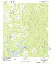
1978 Map of Lake Tuscaloosa North
USGS Topo · Published 1979About this map
North River meanders southward through northern Tuscaloosa County, feeding into the northern reaches of Lake Tuscaloosa by the late 1970s. The landscape is defined by the transition from rural uplands to the reservoir's fingers, which have submerged former valley floors and created new geography like Skelton Bend. The settlement of Samantha serves as a local hub near the western edge of the sheet, connected by a network of winding paths such as Samantha Long Rd and Moores Bridge Road.
Find a feature on this map
44 named features on this map. Tap any name to fly to it.
Don’t see what you’re looking for? This feature index may not catch every label — zoom into the map to look around manually.
Map Details
Editions of this 1978 Lake Tuscaloosa North Map
3 editions found
Other maps of this area

1893 · Jasper
USGS Topo · 1:125,000

1899 · Brookwood
USGS Topo · 1:125,000

1926 · Samantha
USGS Topo · 1:48,000

1928 · Samantha
USGS Topo · 1:62,500

1929 · Searles
USGS Topo · 1:48,000

1934 · Searles
USGS Topo · 1:62,500

1949 · Wiley
USGS Topo · 1:24,000

1951 · Wiley
USGS Topo · 1:24,000

1953 · Birmingham
USGS Topo · 1:250,000

1956 · Birmingham
USGS Topo · 1:250,000