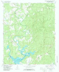
1978 Map of Lake Tuscaloosa North
USGS Topo · Published 1986About this map
Lake Tuscaloosa dominates the southern landscape of this northern Alabama survey, where the winding North River feeds into the reservoir. The topography is defined by the river’s deep meanders, notably at Skelton Bend, and a network of named waterways including Turkey Creek and Cripple Creek. The rural community of Samantha serves as a local hub, with the Samantha (PO) marking the post office location.
Find a feature on this map
54 named features on this map. Tap any name to fly to it.
Don’t see what you’re looking for? This feature index may not catch every label — zoom into the map to look around manually.
Map Details
Editions of this 1978 Lake Tuscaloosa North Map
3 editions found
Other maps of this area

1893 · Jasper
USGS Topo · 1:125,000

1899 · Brookwood
USGS Topo · 1:125,000

1926 · Samantha
USGS Topo · 1:48,000

1928 · Samantha
USGS Topo · 1:62,500

1929 · Searles
USGS Topo · 1:48,000

1934 · Searles
USGS Topo · 1:62,500

1949 · Wiley
USGS Topo · 1:24,000

1951 · Wiley
USGS Topo · 1:24,000

1953 · Birmingham
USGS Topo · 1:250,000

1956 · Birmingham
USGS Topo · 1:250,000