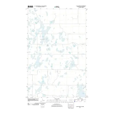
2011 Map of Lake Upsilon
USGS Topo · Published 2011About this map
Wakopa Creek meanders through a dense cluster of glacial potholes and permanent water bodies in this 2011 survey of Rolette County. The landscape is defined by its high density of named lakes, ranging from the large Belcourt Lake in the southeast to the sprawling Oak Lakes and Walker Lake further north. This area serves as a significant recreational and ecological corridor, evidenced by the Gravel Lake Campground and the numerous Bureau of Indian Affairs (B.I.A.) routes that provide access to these remote waters.
Find a feature on this map
46 named features on this map. Tap any name to fly to it.
Don’t see what you’re looking for? This feature index may not catch every label — zoom into the map to look around manually.
Map Details
Editions of this 2011 Lake Upsilon Map
This is the sole edition of this map. No revisions or reprints were ever made.
Other maps of this area

1936 · Lake Upsilon
USGS Topo · 1:48,000

1942 · Lake Upsilon
USGS Topo · 1:62,500

1953 · Devils Lake
USGS Topo · 1:250,000

1955 · Lake Upsilon SW
USGS Topo · 1:24,000

1956 · Devils Lake
USGS Topo · 1:250,000

1968 · Lake Upsilon SE
USGS Topo · 1:24,000
1968 · Carpenter Lake
USGS Topo · 1:24,000
1968 · Lake Upsilon
USGS Topo · 1:24,000

1968 · Belcourt
USGS Topo · 1:24,000

1969 · Saint John
USGS Topo · 1:24,000