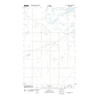
2011 Map of Lake Upsilon SE
USGS Topo · Published 2011About this map
Shell Valley lies at the heart of this North Dakota landscape, situated in an area characterized by a complex network of glacial ponds and wetlands. The topography is dominated by numerous small water bodies and the winding paths of Wolf Creek and Ox Creek, which drain toward larger features like Belcourt Lake and Marion Lakes. This 2011 survey documents a rural infrastructure heavily influenced by the Bureau of Indian Affairs road system, including B I A Road 8 and B I A Road 11.
Find a feature on this map
25 named features on this map. Tap any name to fly to it.
Don’t see what you’re looking for? This feature index may not catch every label — zoom into the map to look around manually.
Map Details
Editions of this 2011 Lake Upsilon SE Map
This is the sole edition of this map. No revisions or reprints were ever made.
Other maps of this area

1936 · Lake Upsilon
USGS Topo · 1:48,000

1942 · Lake Upsilon
USGS Topo · 1:62,500

1953 · Devils Lake
USGS Topo · 1:250,000

1955 · Thorne
USGS Topo · 1:24,000

1955 · Lake Upsilon SW
USGS Topo · 1:24,000

1956 · Devils Lake
USGS Topo · 1:250,000

1968 · Lake Upsilon SE
USGS Topo · 1:24,000
1968 · Carpenter Lake
USGS Topo · 1:24,000
1968 · Lake Upsilon
USGS Topo · 1:24,000

1968 · Belcourt
USGS Topo · 1:24,000