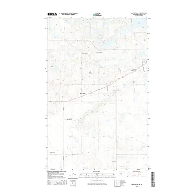
2014 Map of Lake Upsilon SE
USGS Topo · Published 2014About this map
Belcourt and the surrounding plateau of the Turtle Mountains define this northern North Dakota landscape in the early 21st century. The map highlights the intersection of local and tribal infrastructure, with numerous Bureau of Indian Affairs routes like Bia-10 and Bia-12 threading through the undulating terrain. To the west, the community of Shell Valley sits along the upper reaches of Wolf Cr, which drains the glacial prairie potholes common to this region. Genealogy and local history are anchored by landmarks such as White Stone Cem and Saint Anns Addition Cem, while water bodies like Belcourt Lake and the Marion Lakes cluster in the north. The presence of Center Site and several unnamed water features illustrates the complex hydrography of the Turtle Mountain area before the terrain drops toward the plains.
Find a feature on this map
35 named features on this map. Tap any name to fly to it.
Don’t see what you’re looking for? This feature index may not catch every label — zoom into the map to look around manually.
Map Details
Editions of this 2014 Lake Upsilon SE Map
This is the sole edition of this map. No revisions or reprints were ever made.
Other maps of this area

1936 · Lake Upsilon
USGS Topo · 1:48,000

1942 · Lake Upsilon
USGS Topo · 1:62,500

1953 · Devils Lake
USGS Topo · 1:250,000

1955 · Thorne
USGS Topo · 1:24,000

1955 · Lake Upsilon SW
USGS Topo · 1:24,000

1956 · Devils Lake
USGS Topo · 1:250,000

1968 · Lake Upsilon SE
USGS Topo · 1:24,000
1968 · Carpenter Lake
USGS Topo · 1:24,000
1968 · Lake Upsilon
USGS Topo · 1:24,000

1968 · Belcourt
USGS Topo · 1:24,000