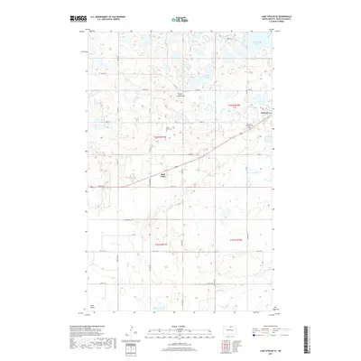
2017 Map of Lake Upsilon SE
USGS Topo · Published 2017About this map
The Turtle Mountains provide a distinct rolling landscape in this portion of Rolette County, characterized by a dense network of glacial wetlands and small basins including Marion Lakes and Belcourt Lake. The settlement of Belcourt occupies the northeastern section, showing a detailed street layout near the Saint Anns Addition Cem, while the community of Shell Valley is situated further south along the junction of 281 and Old Hwy 5. Local genealogy and land use are anchored by sites such as the White Stone Cem and an extensive grid of Bureau of Indian Affairs routes like Bia RD 6 and Bia RD 21. This 2017 survey details a landscape where water management and tribal infrastructure are central, with several branches of Wolf Cr and Ox Cr draining the elevated terrain toward the south and east.
Find a feature on this map
23 named features on this map. Tap any name to fly to it.
Don’t see what you’re looking for? This feature index may not catch every label — zoom into the map to look around manually.
Map Details
Editions of this 2017 Lake Upsilon SE Map
This is the sole edition of this map. No revisions or reprints were ever made.
Other maps of this area

1936 · Lake Upsilon
USGS Topo · 1:48,000

1942 · Lake Upsilon
USGS Topo · 1:62,500

1953 · Devils Lake
USGS Topo · 1:250,000

1955 · Thorne
USGS Topo · 1:24,000

1955 · Lake Upsilon SW
USGS Topo · 1:24,000

1956 · Devils Lake
USGS Topo · 1:250,000

1968 · Lake Upsilon SE
USGS Topo · 1:24,000
1968 · Carpenter Lake
USGS Topo · 1:24,000
1968 · Lake Upsilon
USGS Topo · 1:24,000

1968 · Belcourt
USGS Topo · 1:24,000