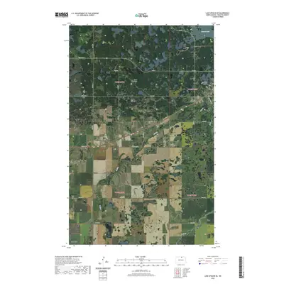
2020 Map of Lake Upsilon SE
USGS Topo · Published 2020About this map
Turtle Mountains provide a dramatic backdrop to the wooded and wetland-filled landscape of Rolette County, where the settlement of Shell Valley serves as a local hub. This modern-era survey documents a region defined by its complex hydrography and deep cultural history within the Turtle Mountain Reservation. Near the northeastern corner, Belcourt Lake sits adjacent to important local landmarks including the Saint Ann Catholic Original Cem and the Saint Anns Addition Cem. The transit network is a blend of tribal and state routes, including Bia Rd 6 and Old Hwy 5, which navigate the dense clusters of smaller lakes and kettle holes characteristic of the local terrain. Further south, Wolf Cr winds through more open agricultural land, passing near the White Stone Cem and intersecting the residential corridors of Wolf Creek Dr.
Find a feature on this map
27 named features on this map. Tap any name to fly to it.
Don’t see what you’re looking for? This feature index may not catch every label — zoom into the map to look around manually.
Map Details
Editions of this 2020 Lake Upsilon SE Map
This is the sole edition of this map. No revisions or reprints were ever made.
Other maps of this area

1936 · Lake Upsilon
USGS Topo · 1:48,000

1942 · Lake Upsilon
USGS Topo · 1:62,500

1953 · Devils Lake
USGS Topo · 1:250,000

1955 · Thorne
USGS Topo · 1:24,000

1955 · Lake Upsilon SW
USGS Topo · 1:24,000

1956 · Devils Lake
USGS Topo · 1:250,000

1968 · Lake Upsilon SE
USGS Topo · 1:24,000
1968 · Carpenter Lake
USGS Topo · 1:24,000
1968 · Lake Upsilon
USGS Topo · 1:24,000

1968 · Belcourt
USGS Topo · 1:24,000