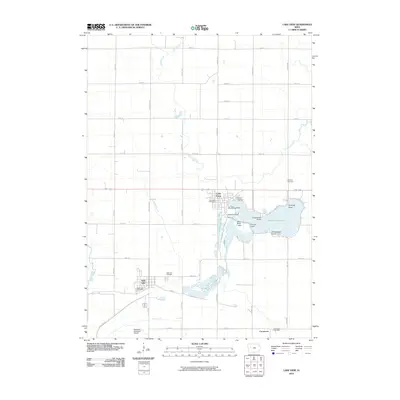
2010 Map of Lake View
USGS Topo · Published 2010About this map
Black Hawk Lake serves as the focal point of this western Iowa landscape, surrounded by a complex shoreline featuring Ice House Point, Hunters Point, and Drillings Point. The town of Lake View is situated on the northwestern shore, while the community of Wall Lake lies to the southwest, connected by a network of section-line roads like Mace Ave and Otter Ave. The area’s water management history is visible through Drainage Ditch 71 and Drainage Ditch 60, which intersect the agricultural fields north of the lakes.
Find a feature on this map
45 named features on this map. Tap any name to fly to it.
Don’t see what you’re looking for? This feature index may not catch every label — zoom into the map to look around manually.
Map Details
Editions of this 2010 Lake View Map
This is the sole edition of this map. No revisions or reprints were ever made.
Other maps of this area

1954 · Fort Dodge
USGS Topo · 1:250,000

1957 · Fort Dodge
USGS Topo · 1:250,000

1958 · Fort Dodge
USGS Topo · 1:250,000

1980 · Odebolt East
USGS Topo · 1:24,000

1980 · Sac City East
USGS Topo · 1:24,000

1980 · Breda
USGS Topo · 1:24,000

1980 · Grant City
USGS Topo · 1:24,000

1980 · Early
USGS Topo · 1:24,000

1980 · Lake View
USGS Topo · 1:24,000
1980 · Sac City West
USGS Topo · 1:24,000