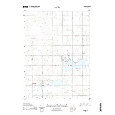
2018 Map of Lake View
USGS Topo · Published 2018About this map
Lake View and the surrounding agricultural plains of Sac County are defined by a complex hydraulic network of glacial lakes and managed drainage. The landscape is centered on Black Hawk Lake, where numerous named peninsulas like Ice House Point, Lakewood Point, and Provost Point mark the irregular shoreline. This water system is supported by the Wall Lake Inlet and drained via the Wall Lake Outlet, reflecting the region's long history of water management for both recreation and agriculture. To the southwest, the town of Wall Lake sits near the headwaters of the Boyer River and Lime Cr, situated amidst a grid of section-line roads and drainage infrastructure such as Drainage Ditch 60. Smaller communities like Carnarvon and local landmarks including Ferguson Cem and Wall Lake Cem provide key points of reference for genealogists and local historians studying the rural settlement patterns of western Iowa.
Find a feature on this map
66 named features on this map. Tap any name to fly to it.
Don’t see what you’re looking for? This feature index may not catch every label — zoom into the map to look around manually.
Map Details
Editions of this 2018 Lake View Map
This is the sole edition of this map. No revisions or reprints were ever made.
Other maps of this area

1954 · Fort Dodge
USGS Topo · 1:250,000

1957 · Fort Dodge
USGS Topo · 1:250,000

1958 · Fort Dodge
USGS Topo · 1:250,000

1980 · Odebolt East
USGS Topo · 1:24,000

1980 · Sac City East
USGS Topo · 1:24,000

1980 · Breda
USGS Topo · 1:24,000

1980 · Grant City
USGS Topo · 1:24,000

1980 · Early
USGS Topo · 1:24,000

1980 · Lake View
USGS Topo · 1:24,000
1980 · Sac City West
USGS Topo · 1:24,000