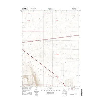
2013 Map of Lake Walcott SW
USGS Topo · Published 2013About this map
Cotterel Mountains define the southern landscape of this 2013 survey, where the small settlement of Cotterel sits at a crucial junction near the intersection of modern transit and pioneer history. The map captures a high-desert environment in Cassia County, marked by distinctive landforms such as Guinn Canyon and Horse Butte. One of the most significant historical markers shown is the Emigrant Trl, which cuts across the eastern sections of the quadrangle. This alignment provides a direct spatial link between the historic wagon routes of the 19th century and the contemporary road network, including N Yale Rd and E Baseline Rd. The survey illustrates how the grid of the Public Land Survey System, including t10s r25e and t10s r26e, organizes this expansive terrain for modern management while the old trails still follow the natural contours of the land.
Find a feature on this map
16 named features on this map. Tap any name to fly to it.
Don’t see what you’re looking for? This feature index may not catch every label — zoom into the map to look around manually.
Map Details
Editions of this 2013 Lake Walcott SW Map
This is the sole edition of this map. No revisions or reprints were ever made.
Other maps of this area

1954 · Pocatello
USGS Topo · 1:250,000

1958 · Pocatello
USGS Topo · 1:250,000

1959 · Lake Walcott
USGS Topo · 1:62,500

1964 · Rupert SE
USGS Topo · 1:24,000

1964 · Acequia
USGS Topo · 1:24,000

1968 · Malta NE
USGS Topo · 1:24,000

1968 · Idahome
USGS Topo · 1:24,000

1968 · Albion
USGS Topo · 1:24,000
1984 · Lake Walcott West
USGS Topo · 1:24,000
1984 · Lake Walcott SE
USGS Topo · 1:24,000