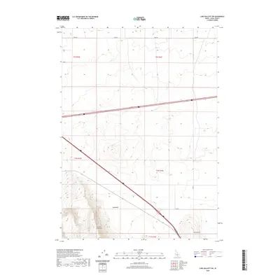
2020 Map of Lake Walcott SW
USGS Topo · Published 2020About this map
The Cotterel Mountains define the southwestern landscape of this region, rising above the surrounding high desert plains. In the central valley, the small settlement of Cotterel sits at a strategic transit point where local routes like Yale Rd intersect with the primary transportation corridor. The map illustrates a sparse but deliberate human footprint, where the geometry of public land survey sections—marked by t9s r26e and t10s r26e—imposes order on the terrain. East of the mountains, the isolated elevation of Horse Butte stands as a prominent landmark for travelers and local residents alike. This 2020 data captures the area as a high-altitude agricultural and ranching landscape, shaped by the path of major Idaho interstates and maintained through a network of secondary roads such as 2050 Rd.
Find a feature on this map
12 named features on this map. Tap any name to fly to it.
Don’t see what you’re looking for? This feature index may not catch every label — zoom into the map to look around manually.
Map Details
Editions of this 2020 Lake Walcott SW Map
This is the sole edition of this map. No revisions or reprints were ever made.
Other maps of this area

1954 · Pocatello
USGS Topo · 1:250,000

1958 · Pocatello
USGS Topo · 1:250,000

1959 · Lake Walcott
USGS Topo · 1:62,500

1964 · Rupert SE
USGS Topo · 1:24,000

1964 · Acequia
USGS Topo · 1:24,000

1968 · Malta NE
USGS Topo · 1:24,000

1968 · Idahome
USGS Topo · 1:24,000

1968 · Albion
USGS Topo · 1:24,000
1984 · Lake Walcott West
USGS Topo · 1:24,000
1984 · Lake Walcott SE
USGS Topo · 1:24,000