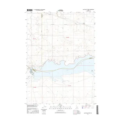
2017 Map of Lake Walcott West
USGS Topo · Published 2017About this map
Lake Walcott dominates this landscape along the border of Cassia, Minidoka, and Blaine Counties. This section of the Snake River is defined by a sophisticated water management system designed for high-desert agriculture, featuring the Main North Side Canal, Main South Side Canal, and the Gravity Canal. These engineering works transformed the surrounding plains, allowing for the establishment of ranches and rural settlements like Hawley in the northeast. The shoreline is marked by the Lakeview Trail, while the reservoir itself contains Bird Island, providing a sanctuary amidst the irrigated tracts. Transportation in the area relies on a grid of rural routes including Main Line Ranch Rd and River Ranch Rd, which serve the expansive ranch lands that stretch north from the river banks.
Find a feature on this map
29 named features on this map. Tap any name to fly to it.
Don’t see what you’re looking for? This feature index may not catch every label — zoom into the map to look around manually.
Map Details
Editions of this 2017 Lake Walcott West Map
This is the sole edition of this map. No revisions or reprints were ever made.
Other maps of this area

1954 · Pocatello
USGS Topo · 1:250,000

1958 · Pocatello
USGS Topo · 1:250,000

1959 · Lake Walcott
USGS Topo · 1:62,500

1964 · Rupert SE
USGS Topo · 1:24,000

1964 · Acequia
USGS Topo · 1:24,000

1972 · Schodde Well
USGS Topo · 1:24,000

1972 · Minidoka
USGS Topo · 1:24,000

1972 · Max
USGS Topo · 1:24,000
1984 · Lake Walcott West
USGS Topo · 1:24,000
1984 · Lake Walcott SE
USGS Topo · 1:24,000