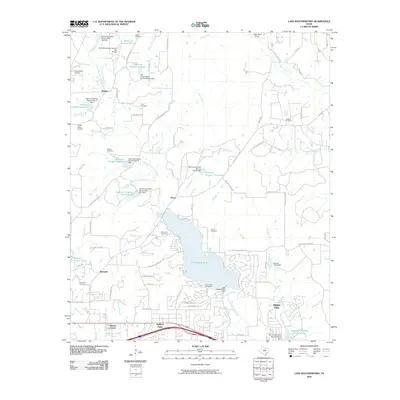
2010 Map of Lake Weatherford
USGS Topo · Published 2010About this map
Lake Weatherford serves as the central focal point for this Parker County landscape, where the waters of the Clear Fork Trinity River are harnessed by the Lake Weatherford Dam. The surrounding topography is marked by a transition from traditional rural homesteads and family cemeteries to modern suburban developments and specialized recreational sites. In the southern corridor, the settlements of Hudson Oaks and Willow Park demonstrate residential growth along major transit lines, while smaller locales like Dicey, Wampler, and Punkin Center maintain their distinct geographic identities.
Find a feature on this map
86 named features on this map. Tap any name to fly to it.
Don’t see what you’re looking for? This feature index may not catch every label — zoom into the map to look around manually.
Map Details
Editions of this 2010 Lake Weatherford Map
This is the sole edition of this map. No revisions or reprints were ever made.
Other maps of this area

1891 · Weatherford
USGS Topo · 1:125,000

1893 · Weatherford
USGS Topo · 1:125,000

1931 · Dennis
USGS Topo · 1:62,500

1932 · Springtown
USGS Topo · 1:62,500

1954 · Dallas
USGS Topo · 1:250,000

1955 · Aledo
USGS Topo · 1:24,000

1955 · Azle
USGS Topo · 1:24,000
1955 · Springtown SE
USGS Topo · 1:24,000

1958 · Dallas
USGS Topo · 1:250,000

1958 · Springtown
USGS Topo · 1:24,000