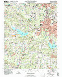
1993 Map of Lake Wheeler
USGS Topo · Published 1999About this map
Raleigh and Garner extend their reach into the surrounding countryside during the early 1990s, where sprawling residential developments like Greenbrier Estates and Echo Heights begin to overtake older agricultural landscapes. Central to the area is the expansive Lake Wheeler, a major water feature managed by the North Carolina State University Research Units. This research landscape is punctuated by historical landmarks such as Yates Millpond and the State School for Blind and Deaf.
Find a feature on this map
74 named features on this map. Tap any name to fly to it.
Don’t see what you’re looking for? This feature index may not catch every label — zoom into the map to look around manually.
Map Details
Editions of this 1993 Lake Wheeler Map
This is the sole edition of this map. No revisions or reprints were ever made.
Other maps of this area

1943 · Durham South
USGS Topo · 1:62,500

1943 · Raleigh
USGS Topo · 1:62,500

1951 · Raleigh
USGS Topo · 1:62,500

1951 · Durham South
USGS Topo · 1:62,500

1953 · Raleigh
USGS Topo · 1:250,000

1954 · Raleigh
USGS Topo · 1:250,000

1964 · Lake Wheeler
USGS Topo · 1:24,000

1964 · Garner
USGS Topo · 1:24,000

1964 · Angier
USGS Topo · 1:24,000

1964 · Edmondson
USGS Topo · 1:24,000