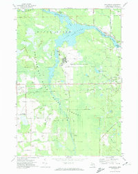
1971 Map of Lake Winyah
USGS Topo · Published 1974About this map
The Thunder Bay River dominates this Alpena County landscape, widening into the sprawling Lake Winyah behind the Norway Point Dam Powerplant. This 1970s survey documents a region defined by its industrial and recreational infrastructure, from the large Phelps Collins Airport at the center to the Drive-in Theater along Glennie Road. Small rural centers and family-named roads provide a window into local genealogy, including Wilson Cem and the Townhall near the settlement of Butterfield. To the west, the industrial activity at Paxton and the nearby Quarry contrast with the protected lands of the Mackinac State Forest. The map also preserves the route of an Old Railroad Grade and the Indian Reserve boundary, illustrating the layered history of land use and transport in this part of Michigan.
Find a feature on this map
55 named features on this map. Tap any name to fly to it.
Don’t see what you’re looking for? This feature index may not catch every label — zoom into the map to look around manually.
Map Details
Editions of this 1971 Lake Winyah Map
2 editions found
Other maps of this area

1954 · Tawas City
USGS Topo · 1:250,000

1954 · Alpena
USGS Topo · 1:250,000

1957 · Alpena
USGS Topo · 1:250,000

1958 · Alpena
USGS Topo · 1:250,000

1958 · Tawas City
USGS Topo · 1:250,000

1969 · Alpena
USGS Topo · 1:250,000

1971 · Lake Winyah
USGS Topo · 1:24,000

1971 · Long Lake West
USGS Topo · 1:24,000

1971 · Alpena
USGS Topo · 1:24,000

1971 · Polaski
USGS Topo · 1:24,000