
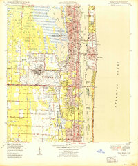
1949 Map of Lake Worth
USGS Topo · Published 1949About this map
The coastal corridor of Palm Beach county is captured here in the late 1940s, a period when local infrastructure was rapidly evolving between the shoreline and the interior wetlands. Along the coast, the barrier land of Hypoluxo Island separates the salt spray of the Atlantic Ocean from the tidal waters of Lake Worth. The map details the parallel transportation arteries that drove development in this era, including the Florida East Coast and Seaboard Air Line railroads, alongside the Intra-Coastal Waterway.
Find a feature on this map
19 named features on this map. Tap any name to fly to it.
Don’t see what you’re looking for? This feature index may not catch every label — zoom into the map to look around manually.
Map Details
Editions of this 1949 Lake Worth Map
This is the sole edition of this map. No revisions or reprints were ever made.
Other maps of this area

1945 · Greenacres City
USGS Topo · 1:24,000

1945 · Lake Worth
USGS Topo · 1:24,000

1946 · Palm Beach Farms
USGS Topo · 1:24,000

1946 · Palm Beach
USGS Topo · 1:24,000

1947 · Delmar Farms
USGS Topo · 1:24,000

1949 · Palm Beach Farms
USGS Topo · 1:24,000

1949 · Delmar Farms
USGS Topo · 1:24,000

1950 · Delray Beach
USGS Topo · 1:24,000

1950 · Greenacres City
USGS Topo · 1:24,000
1950 · Palm Beach
USGS Topo · 1:24,000