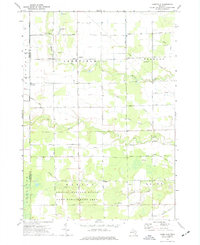
1973 Map of Lakefield
USGS Topo · Published 1977About this map
Lakefield and the surrounding township appear as a patchwork of agricultural fields and riparian corridors in the early 1970s. The landscape is defined by its complex drainage network, where the Bad River and its numerous tributaries, including Beaver Creek and Potato Creek, wind through the low-lying terrain. This era of Saginaw County history is captured just as conservation efforts were firmly established in the south, evidenced by the expansive Gratiot-Saginaw State Game Management Area. Local genealogy is well-represented by long-standing landmarks such as Sacred Heart Cem and Lakefield Cem, while small settlements like Galloway and Fordney anchor the rural road grid. The map also reveals the area's geological utility through scattered Gravel Pits and Sandpits, which supported the infrastructure of these mid-Michigan communities.
Find a feature on this map
38 named features on this map. Tap any name to fly to it.
Don’t see what you’re looking for? This feature index may not catch every label — zoom into the map to look around manually.
Map Details
Editions of this 1973 Lakefield Map
This is the sole edition of this map. No revisions or reprints were ever made.
Other maps of this area

1917 · Chesaning
USGS Topo · 1:62,500

1917 · St. Charles
USGS Topo · 1:62,500

1918 · Elsie
USGS Topo · 1:62,500

1934 · Merrill
USGS Topo · 1:62,500

1937 · Merrill
USGS Topo · 1:62,500

1943 · Chesaning
USGS Topo · 1:62,500

1943 · St. Charles
USGS Topo · 1:62,500

1943 · Elsie
USGS Topo · 1:62,500

1954 · Midland
USGS Topo · 1:250,000

1958 · Midland
USGS Topo · 1:250,000