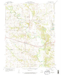
1959 Map of Lakenan
USGS Topo · Published 1960About this map
The North Fork Salt River winds through Shelby County, defining the agricultural landscape of this northern Missouri region during the late 1950s. The village of Lakenan serves as a central point along the Chicago Burlington and Quincy railroad, which cuts east-to-west across the terrain. This survey captures a rural network of small school districts and community centers, including Beatley Sch, Givan Sch, Hightower Sch, and Greenwell Sch, reflecting the localized social structure before the widespread consolidation of country schools.
Find a feature on this map
29 named features on this map. Tap any name to fly to it.
Don’t see what you’re looking for? This feature index may not catch every label — zoom into the map to look around manually.
Map Details
Editions of this 1959 Lakenan Map
3 editions found
Other maps of this area

1903 · Palmyra
USGS Topo · 1:125,000

1948 · Quincy
USGS Topo · 1:250,000

1953 · Moberly
USGS Topo · 1:250,000

1954 · Moberly
USGS Topo · 1:250,000

1956 · Quincy
USGS Topo · 1:250,000

1957 · Moberly
USGS Topo · 1:250,000

1959 · Shelbina
USGS Topo · 1:24,000

1959 · Lakenan
USGS Topo · 1:24,000

1959 · Hunnewell
USGS Topo · 1:24,000

1960 · Moberly
USGS Topo · 1:250,000