
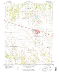
1959 Map of Shelbina
USGS Topo · Published 1960About this map
The Chicago Burlington and Quincy railroad cuts a straight line through the heart of Shelby County, anchoring the commercial and social life of Shelbina. In this late 1950s landscape, the town is a dense center of activity, featuring the County Fairground, a Waterworks, and the Shelbina Lake Park to the north. Outside the town limits, the terrain transitions into a mosaic of drainage basins fed by the North Fork Salt River and the meandering Crooked Creek.
Find a feature on this map
34 named features on this map. Tap any name to fly to it.
Don’t see what you’re looking for? This feature index may not catch every label — zoom into the map to look around manually.
Map Details
Editions of this 1959 Shelbina Map
2 editions found
Other maps of this area

1903 · Palmyra
USGS Topo · 1:125,000

1948 · Quincy
USGS Topo · 1:250,000

1953 · Moberly
USGS Topo · 1:250,000

1954 · Moberly
USGS Topo · 1:250,000

1956 · Quincy
USGS Topo · 1:250,000

1957 · Moberly
USGS Topo · 1:250,000

1958 · Lentner
USGS Topo · 1:24,000

1959 · Lakenan
USGS Topo · 1:24,000
1959 · Woodlawn
USGS Topo · 1:24,000

1960 · Moberly
USGS Topo · 1:250,000