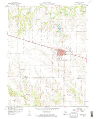
1959 Map of Shelbina
USGS Topo · Published 1960About this map
The Chicago Burlington and Quincy railroad corridor serves as the primary East-West axis for this late-1950s survey of Shelby County. Shelbina stands as the central hub, showing a structured town grid complete with its High Sch, County Fairground, and civic utilities like the Waterworks and Sewage Disposal. Outside the main settlement, the landscape transitions into a network of small watercourses, including Brush Creek and Clear Creek, which feed into the Salt River system.
Find a feature on this map
32 named features on this map. Tap any name to fly to it.
Don’t see what you’re looking for? This feature index may not catch every label — zoom into the map to look around manually.
Map Details
Editions of this 1959 Shelbina Map
2 editions found
Other maps of this area

1903 · Palmyra
USGS Topo · 1:125,000

1948 · Quincy
USGS Topo · 1:250,000

1953 · Moberly
USGS Topo · 1:250,000

1954 · Moberly
USGS Topo · 1:250,000

1956 · Quincy
USGS Topo · 1:250,000

1957 · Moberly
USGS Topo · 1:250,000

1958 · Lentner
USGS Topo · 1:24,000

1959 · Shelbina
USGS Topo · 1:24,000

1959 · Lakenan
USGS Topo · 1:24,000
1959 · Woodlawn
USGS Topo · 1:24,000