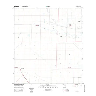
2015 Map of Lakeport
USGS Topo · Published 2015About this map
Lakeport sits at the northern edge of this coastal landscape, where the massive Herbert Hoover Dyke creates a definitive boundary against the wetlands. This 2015 survey reveals a terrain defined by water management and natural drainage, characterized by features like Gator Slough and Nicodemus Slough. The winding course of Fisheating Creek meanders toward the shore, passing notable topographic landmarks such as Sheridan Bend and the historically significant Fort Centre site.
Find a feature on this map
24 named features on this map. Tap any name to fly to it.
Don’t see what you’re looking for? This feature index may not catch every label — zoom into the map to look around manually.
Map Details
Editions of this 2015 Lakeport Map
This is the sole edition of this map. No revisions or reprints were ever made.
Other maps of this area

1953 · Brighton SW
USGS Topo · 1:24,000

1953 · Brighton SE
USGS Topo · 1:24,000

1956 · West Palm Beach
USGS Topo · 1:250,000

1956 · Fort Pierce
USGS Topo · 1:250,000

1957 · West Palm Beach
USGS Topo · 1:250,000

1957 · Venus
USGS Topo · 1:24,000

1958 · Fort Pierce
USGS Topo · 1:250,000

1958 · West Palm Beach
USGS Topo · 1:250,000

1958 · Goodno
USGS Topo · 1:24,000
1958 · Palmdale
USGS Topo · 1:24,000