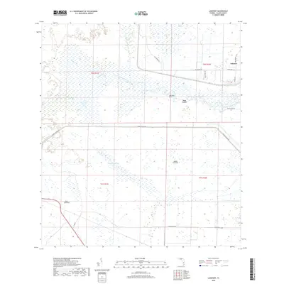
2018 Map of Lakeport
USGS Topo · Published 2018About this map
Fisheating Creek winds through a vast expanse of wetlands and marshy hammocks in this Glades County landscape. The settlement of Lakeport and the archaeological site of Fort Centre anchor the eastern side of the survey, revealing the intersection of modern residence and prehistoric significance. The massive Herbert Hoover Dike cuts a straight path across the terrain, a dominant engineering feature managing the waters of the northern Everglades ecosystem.
Find a feature on this map
25 named features on this map. Tap any name to fly to it.
Don’t see what you’re looking for? This feature index may not catch every label — zoom into the map to look around manually.
Map Details
Editions of this 2018 Lakeport Map
This is the sole edition of this map. No revisions or reprints were ever made.
Other maps of this area

1953 · Brighton SW
USGS Topo · 1:24,000

1953 · Brighton SE
USGS Topo · 1:24,000

1956 · West Palm Beach
USGS Topo · 1:250,000

1956 · Fort Pierce
USGS Topo · 1:250,000

1957 · West Palm Beach
USGS Topo · 1:250,000

1957 · Venus
USGS Topo · 1:24,000

1958 · Fort Pierce
USGS Topo · 1:250,000

1958 · West Palm Beach
USGS Topo · 1:250,000

1958 · Goodno
USGS Topo · 1:24,000
1958 · Palmdale
USGS Topo · 1:24,000