
1979 Map of Lakeside
USGS Topo · Published 1979About this map
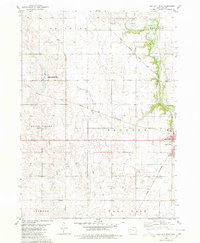
Storm Lake dominates the northern landscape, its southern shoreline defined by the Storm Lake State Wildlife Management Area and the community of Lakeside. The area reflects a late-1970s balance of recreation and education, featuring the Iowa Central Community College campus and public amenities like a Drive-in Theater and a lakeside Boat Ramp. Moving south from the water, the terrain transitions into a grid of agricultural sections across Hayes and Eden townships.
Find a feature on this map
26 named features on this map. Tap any name to fly to it.
Don’t see what you’re looking for? This feature index may not catch every label — zoom into the map to look around manually.
Map Details
Editions of this 1979 Lakeside Map
This is the sole edition of this map. No revisions or reprints were ever made.
Other maps of this area

1954 · Fort Dodge
USGS Topo · 1:250,000

1957 · Fort Dodge
USGS Topo · 1:250,000

1958 · Fort Dodge
USGS Topo · 1:250,000

1979 · Storm Lake
USGS Topo · 1:24,000

1979 · Newell West
USGS Topo · 1:24,000

1979 · Alta
USGS Topo · 1:24,000

1979 · Schaller North
USGS Topo · 1:24,000

1979 · Storm Lake NE
USGS Topo · 1:24,000

1980 · Early
USGS Topo · 1:24,000
1980 · Sac City West
USGS Topo · 1:24,000