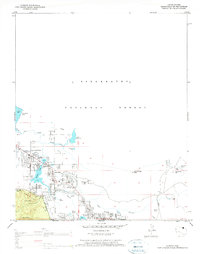
1976 Map of Lakeside
USGS Topo · Published 1977About this map
The Mogollon Rim forms a dramatic southwestern boundary on this map, marking the high edge of the Colorado Plateau as it drops away into the Fort Apache Indian Reservation. In the mid-1970s, the adjacent communities of Lakeside and Pinetop are shown as distinct hubs of activity, shaped by the presence of numerous water sources such as Rainbow Lake and Scott Reservoir. This area within the Sitgreaves National Forest was undergoing notable residential and educational development, evidenced by the central location of Blue Ridge HS.
Find a feature on this map
32 named features on this map. Tap any name to fly to it.
Don’t see what you’re looking for? This feature index may not catch every label — zoom into the map to look around manually.
Map Details
Editions of this 1976 Lakeside Map
2 editions found
Other maps of this area

1886 · St Johns
USGS Topo · 1:250,000

1886 · Holbrook
USGS Topo · 1:250,000

1892 · St Johns
USGS Topo · 1:250,000

1893 · Holbrook
USGS Topo · 1:250,000

1954 · Holbrook
USGS Topo · 1:250,000

1954 · Saint Johns
USGS Topo · 1:250,000

1957 · Holbrook
USGS Topo · 1:250,000

1957 · Saint Johns
USGS Topo · 1:250,000

1958 · Saint Johns
USGS Topo · 1:250,000

1958 · Holbrook
USGS Topo · 1:250,000