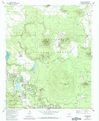
1976 Map of Lakeside
USGS Topo · Published 1985About this map
Lakeside and Pinetop anchor this high-country landscape, where the northern border of the Fort Apache Indian Reservation meets the Sitgreaves National Forest. The map shows a region defined by its water management and timber, with numerous tanks and reservoirs like Scott Reservoir and Rainbow Lake supporting the local settlements. Notable landmarks for local historians include the Blue Ridge HS, a Cemetery, and the Springer Mtn Lookout situated atop the volcanic terrain. The presence of several cinder and borrow pits near Porter Mtn and Twin Knolls points to the area's geological and extractive history. This 1976 revision, based on earlier surveys and updated with 1982 aerial photography, documents the expansion of residential footprints and campgrounds as the area transitioned into a significant mountain retreat and residential hub.
Find a feature on this map
60 named features on this map. Tap any name to fly to it.
Don’t see what you’re looking for? This feature index may not catch every label — zoom into the map to look around manually.
Map Details
Editions of this 1976 Lakeside Map
2 editions found

Other maps of this area

1886 · St Johns
USGS Topo · 1:250,000

1886 · Holbrook
USGS Topo · 1:250,000

1892 · St Johns
USGS Topo · 1:250,000

1893 · Holbrook
USGS Topo · 1:250,000

1954 · Holbrook
USGS Topo · 1:250,000

1954 · Saint Johns
USGS Topo · 1:250,000

1957 · Holbrook
USGS Topo · 1:250,000

1957 · Saint Johns
USGS Topo · 1:250,000

1958 · Saint Johns
USGS Topo · 1:250,000

1958 · Holbrook
USGS Topo · 1:250,000