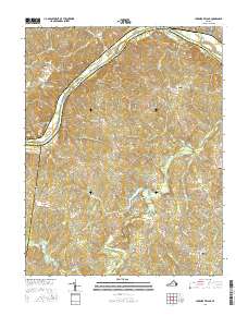
2016 Map of Lakeside Village
USGS Topo · Published 2016About this map
The James River flows through the northern reaches of this territory, where the historic town of Columbia sits at the junction of Fluvanna and Goochland counties. This 2016 survey documents the shifting riparian environment, featuring Boatwrights Island and Spicers Island mid-stream. To the south, the landscape is defined by the Willis River and its complex network of tributaries like Big Cattail Cr and Snowquarter Cr.
Find a feature on this map
66 named features on this map. Tap any name to fly to it.
Don’t see what you’re looking for? This feature index may not catch every label — zoom into the map to look around manually.
Map Details
Editions of this 2016 Lakeside Village Map
This is the sole edition of this map. No revisions or reprints were ever made.
Other maps of this area

1891 · Palmyra
USGS Topo · 1:125,000

1895 · Palmyra
USGS Topo · 1:125,000

1897 · Palmyra
USGS Topo · 1:125,000

1943 · Scottsville
USGS Topo · 1:62,500

1946 · Scottsville
USGS Topo · 1:62,500

1947 · Roanoke
USGS Topo · 1:250,000

1950 · Dillwyn
USGS Topo · 1:62,500

1958 · Dillwyn
USGS Topo · 1:62,500

1959 · Roanoke
USGS Topo · 1:250,000

1960 · Columbia
USGS Topo · 1:62,500