
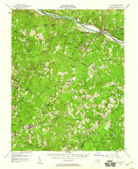
1958 Map of Dillwyn
USGS Topo · Published 1960About this map
The James River corridor defines the northern boundary of this central Virginia landscape, where the Chesapeake and Ohio railroad tracks trace the riverbank past New Canton and Bremo Bluff. The presence of the Lower Bremo Mansion and the John H. Cocke Memorial Bridge highlights the region's deep historical roots near the river. Moving south into the heart of Buckingham County, the terrain is shaped by the winding Slate River and an intricate network of rural settlements and family-named landmarks. The map documents a mid-century community structure tied to small crossroads like Diana Mills, Arvonia, and Sprouses Corner. Local education and faith are represented by numerous sites such as Woodson High Sch and Mourning Valley Ch Cem. The southern portion of the sheet is dominated by the Buckingham State Forest, illustrating the importance of timber and natural resource management to the local economy during the late 1950s.
Find a feature on this map
128 named features on this map. Tap any name to fly to it.
Don’t see what you’re looking for? This feature index may not catch every label — zoom into the map to look around manually.
Map Details
Editions of this 1958 Dillwyn Map
2 editions found
Other maps of this area

1891 · Palmyra
USGS Topo · 1:125,000

1891 · Farmville
USGS Topo · 1:125,000

1892 · Buckingham
USGS Topo · 1:125,000

1892 · Appomattox
USGS Topo · 1:125,000

1893 · Farmville
USGS Topo · 1:125,000

1895 · Palmyra
USGS Topo · 1:125,000

1897 · Palmyra
USGS Topo · 1:125,000

1929 · Covesville
USGS Topo · 1:62,500

1935 · Covesville
USGS Topo · 1:62,500

1943 · Scottsville
USGS Topo · 1:62,500