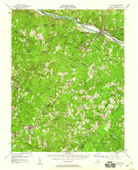
1958 Map of Dillwyn
USGS Topo · Published 1960About this map
The Slate River and James River converge in this central Virginia landscape, where the Seven Islands break the river current near the John H. Cocke Memorial Bridge. This 1958 revision reveals a region built on quarrying and agriculture, with Soapstone Quarry and several inactive mines dotting the hills near Arvonia. The industrial footprint of the Chesapeake and Ohio railroad corridor is evident, linking settlements like New Canton and Dillwyn to the broader river economy.
Find a feature on this map
132 named features on this map. Tap any name to fly to it.
Don’t see what you’re looking for? This feature index may not catch every label — zoom into the map to look around manually.
Map Details
Editions of this 1958 Dillwyn Map
2 editions found

Other maps of this area

1891 · Palmyra
USGS Topo · 1:125,000

1891 · Farmville
USGS Topo · 1:125,000

1892 · Buckingham
USGS Topo · 1:125,000

1892 · Appomattox
USGS Topo · 1:125,000

1893 · Farmville
USGS Topo · 1:125,000

1895 · Palmyra
USGS Topo · 1:125,000

1897 · Palmyra
USGS Topo · 1:125,000

1929 · Covesville
USGS Topo · 1:62,500

1935 · Covesville
USGS Topo · 1:62,500

1943 · Scottsville
USGS Topo · 1:62,500