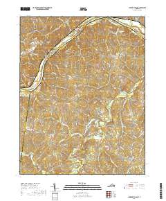
2019 Map of Lakeside Village
USGS Topo · Published 2019About this map
James River frontage and the confluence of the Willis River define this rural Piedmont landscape at the junction of Fluvanna, Goochland, Cumberland, and Buckingham counties. The terrain is characterized by a series of river islands, including Boatwrights Island, Spicers Island, and the larger Elk Island to the northeast. Settlement is concentrated in small crossroads communities like Lakeside Village, Hamilton, and Cloverdale, where the landscape transitions from river bottomlands to the wooded ridges above Big Cattail Creek and Snawquarter Cr. Genealogists will find several family-named landmarks and resting places, such as Harrison Cem, Cochran Cem, and Little Fork Cem. The network of local routes like Columbia Rd and River Rd W connects these upland farms and residences to the water-oriented economy that has long shaped this portion of Central Virginia.
Find a feature on this map
72 named features on this map. Tap any name to fly to it.
Don’t see what you’re looking for? This feature index may not catch every label — zoom into the map to look around manually.
Map Details
Editions of this 2019 Lakeside Village Map
This is the sole edition of this map. No revisions or reprints were ever made.
Other maps of this area

1891 · Palmyra
USGS Topo · 1:125,000

1895 · Palmyra
USGS Topo · 1:125,000

1897 · Palmyra
USGS Topo · 1:125,000

1943 · Scottsville
USGS Topo · 1:62,500

1946 · Scottsville
USGS Topo · 1:62,500

1947 · Roanoke
USGS Topo · 1:250,000

1950 · Dillwyn
USGS Topo · 1:62,500

1958 · Dillwyn
USGS Topo · 1:62,500

1959 · Roanoke
USGS Topo · 1:250,000

1960 · Columbia
USGS Topo · 1:62,500