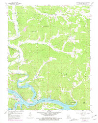
1959 Map of Lakeview Heights
USGS Topo · Published 1981About this map
Lake of the Ozarks and the Osage River dominate the southern portion of this landscape, where the rising waters created complex shorelines like Spring Br Cove and submerged portions of the Cole Camp Creek valley. Further north, the terrain transitions into a network of ridges and hollows defined by the Williams and Cole townships. The map documents a rural community structure through family-named landmarks and local institutions, including the Lutjen Sch and Ross Sch, alongside several small mining operations indicated by Mines and Mine symbols near the northern boundary. Small centers of life like Edmonson and the Ozark Tabernacle anchor the upland roads, while the newer development at Lakeview Heights sits near the water's edge. Genealogists will find value in the specific locations of several burial grounds, including Failer Cem and Mossy Cem, which remain tied to the surrounding drainage of Mossy Creek and Ross Creek.
Find a feature on this map
38 named features on this map. Tap any name to fly to it.
Don’t see what you’re looking for? This feature index may not catch every label — zoom into the map to look around manually.
Map Details
Editions of this 1959 Lakeview Heights Map
3 editions found
Other maps of this area

1887 · Warsaw
USGS Topo · 1:125,000

1894 · Warsaw
USGS Topo · 1:125,000

1935 · Edwards
USGS Topo · 1:24,000

1935 · Dell
USGS Topo · 1:24,000

1935 · Boylers Mill
USGS Topo · 1:24,000

1935 · Knobby Creek
USGS Topo · 1:24,000

1936 · Lakeview Heights
USGS Topo · 1:24,000

1936 · Schuyler
USGS Topo · 1:24,000

1945 · Fristoe
USGS Topo · 1:62,500

1947 · Jefferson City
USGS Topo · 1:250,000