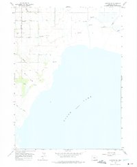
1964 Map of Lakeview SW
USGS Topo · Published 1975About this map
Goose Lake dominates the southern reaches of this landscape, its expansive shoreline meeting a complex system of drainage and irrigation along the western edge. The settlement of West Side serves as the primary human hub, situated along the West Side Road. The topography is defined by the transition from the lake's flat basin to the alluvial plains fed by several perennial watercourses, including Drews Creek, Thomas Creek, and Antelope Creek. Numerous instances of Flowing Wells are mapped throughout the sections, indicating a reliance on artesian water for the agricultural and ranching operations of Lake County. In the western marshes, Barnes Slough and Mill Creek illustrate the natural hydrology that supported early settlement in the high desert, while a Gravel Pit and a isolated Corral suggest the localized industrial and pastoral activities of the mid-1960s.
Find a feature on this map
13 named features on this map. Tap any name to fly to it.
Don’t see what you’re looking for? This feature index may not catch every label — zoom into the map to look around manually.
Map Details
Editions of this 1964 Lakeview SW Map
2 editions found

Other maps of this area

1886 · Alturas
USGS Topo · 1:250,000

1892 · Alturas
USGS Topo · 1:250,000

1954 · Alturas
USGS Topo · 1:250,000

1955 · Klamath Falls
USGS Topo · 1:250,000

1958 · Alturas
USGS Topo · 1:250,000

1958 · Klamath Falls
USGS Topo · 1:250,000

1962 · Alturas
USGS Topo · 1:250,000

1962 · Willow Ranch
USGS Topo · 1:62,500

1962 · South Mountain
USGS Topo · 1:62,500

1964 · Lakeview NE
USGS Topo · 1:24,000