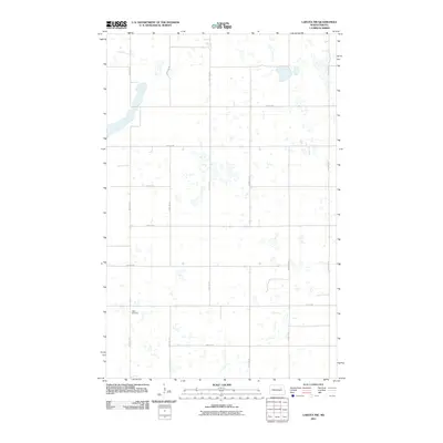
2011 Map of Lakota NW
USGS Topo · Published 2011About this map
Hope Cemetery stands as a quiet focal point in this portion of Nelson County, where the landscape is defined by the rigid geometry of the Public Land Survey System. The map reveals a high concentration of prairie potholes and small wetlands interspersed between a regular grid of gravel roads and section lines. Notable thoroughfares like 99th Ave NE and 50th St NE organize the agricultural space, connecting isolated farmsteads across the rural terrain. This 2011 survey documents a classic North Dakota landscape where water and wind shape the usage of the land, and where the placement of cemeteries like Hope serves as a lasting record of early community settlement patterns and family heritage in a sparsely populated region.
Find a feature on this map
14 named features on this map. Tap any name to fly to it.
Don’t see what you’re looking for? This feature index may not catch every label — zoom into the map to look around manually.
Map Details
Editions of this 2011 Lakota NW Map
This is the sole edition of this map. No revisions or reprints were ever made.
Other maps of this area

1953 · Devils Lake
USGS Topo · 1:250,000

1956 · Devils Lake
USGS Topo · 1:250,000

1970 · Lakota
USGS Topo · 1:24,000
1970 · Bartlett
USGS Topo · 1:24,000

1971 · Brocket
USGS Topo · 1:24,000

1971 · Southam
USGS Topo · 1:24,000
1971 · Doyon
USGS Topo · 1:24,000

1971 · Lakota NW
USGS Topo · 1:24,000

1972 · Derrick SE
USGS Topo · 1:24,000

1972 · Edmore SW
USGS Topo · 1:24,000