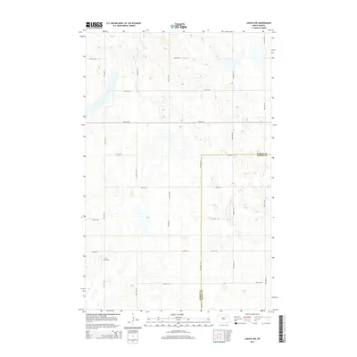
2014 Map of Lakota NW
USGS Topo · Published 2014About this map
The prairie landscape of Nelson County and Ramsey County is defined by a rhythmic grid of rural roads and numerous small depressions and sloughs. This 2014 survey captures the agricultural character of the region, where 57th St Ne serves as one of the few named arteries connecting the open fields. The terrain is marked by hundreds of small glacial kettles, common to this part of North Dakota, creating a complex drainage pattern across the high plains. Unlike the densely settled areas of the state, this quadrangle highlights the isolation and scale of modern midwestern farming where the natural hydrology often dictates the placement of section-line roads and field boundaries.
Find a feature on this map
1 named feature on this map. Tap any name to fly to it.
Don’t see what you’re looking for? This feature index may not catch every label — zoom into the map to look around manually.
Map Details
Editions of this 2014 Lakota NW Map
This is the sole edition of this map. No revisions or reprints were ever made.
Other maps of this area

1953 · Devils Lake
USGS Topo · 1:250,000

1956 · Devils Lake
USGS Topo · 1:250,000

1970 · Lakota
USGS Topo · 1:24,000
1970 · Bartlett
USGS Topo · 1:24,000

1971 · Brocket
USGS Topo · 1:24,000

1971 · Southam
USGS Topo · 1:24,000
1971 · Doyon
USGS Topo · 1:24,000

1971 · Lakota NW
USGS Topo · 1:24,000

1972 · Derrick SE
USGS Topo · 1:24,000

1972 · Edmore SW
USGS Topo · 1:24,000