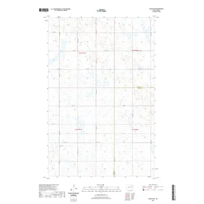
2020 Map of Lakota NW
USGS Topo · Published 2020About this map
The border of Ramsey Co and Nelson Co divides this quiet agricultural landscape in North Dakota. The terrain is defined by a dense network of glacial potholes and wetlands that punctuate the prairie, creating a complex patchwork of land and water that has historically shaped the local farming patterns. Near the intersection of 99th Ave NE and 53rd St NE, Hope Cem provides a specific point of interest for genealogists tracing early families of this rural township. A grid of section-line roads such as 101st Ave NE and 56th St NE provides access to the interior, while Prairie Trl cuts across the central landscape, offering a glimpse into the local travel routes used by residents between these scattered wetland features.
Find a feature on this map
21 named features on this map. Tap any name to fly to it.
Don’t see what you’re looking for? This feature index may not catch every label — zoom into the map to look around manually.
Map Details
Editions of this 2020 Lakota NW Map
This is the sole edition of this map. No revisions or reprints were ever made.
Other maps of this area

1953 · Devils Lake
USGS Topo · 1:250,000

1956 · Devils Lake
USGS Topo · 1:250,000

1970 · Lakota
USGS Topo · 1:24,000
1970 · Bartlett
USGS Topo · 1:24,000

1971 · Brocket
USGS Topo · 1:24,000

1971 · Southam
USGS Topo · 1:24,000
1971 · Doyon
USGS Topo · 1:24,000

1971 · Lakota NW
USGS Topo · 1:24,000

1972 · Derrick SE
USGS Topo · 1:24,000

1972 · Edmore SW
USGS Topo · 1:24,000